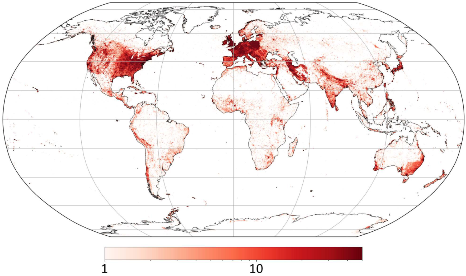
Historical newspapers encode a rich geography that connects local stories to global events - but unlocking this spatial dimension requires resolving place names that have changed, moved, or disappeared over time. This heat map visualizes all geotagged articles in our WikiGazetteer, revealing the remarkable geographic scope of 19th-century British newspapers: from dense coverage of the British Isles to international reporting spanning every continent. Earth's surface was subdivided into 0.25° blocks (approximately 25km), with the logarithmic colorbar showing concentrations of place mentions. Our approach combines three key innovations: an expansive definition of locatable entities (not just cities, but buildings, streets, and regions), knowledge bases derived from contemporaneous historical sources, and contextual information to disambiguate ambiguous place names. By bridging historical and modern geographic resources, this method enables researchers to trace how newspapers constructed spatial narratives during a period of rapid globalization and imperial expansion.
Abstract
Newspapers and their metadata are richly geographical, not only in their distribution but also their content. Attending to these spatial features is a prerequisite in newspaper research. Following other projects to have geoparsed place names in newspapers, we describe our approach to linking historical geospatial information in text to real-world locations which 1) adopts an expansive definition of what counts as a locatable entity; 2) uses knowledge bases derived from contemporaneous sources; and 3) leverages contextual information to disambiguate hard-to-locate places. This method depends on combining historical and non-historical resources and the paper discusses the potential benefits for humanities research.
Keywords: toponym resolution, historical newspapers, geoparsing, digital humanities, geographic information retrieval
Citation
Please cite this work as:
Mariona Coll Ardanuy, Katherine McDonough, Amrey Krause, Daniel C. S. Wilson, Kasra Hosseini, Daniel van Strien. "Resolving places, past and present: toponym resolution in historical British newspapers using multiple resources". Proceedings of the 13th Workshop on Geographic Information Retrieval (2019). https://doi.org/10.1145/3371140.3371143
Or use the BibTeX citation:
@inproceedings{10.1145/3371140.3371143,
author = {Ardanuy, Mariona Coll and McDonough, Katherine and Krause, Amrey and Wilson, Daniel C S and Hosseini, Kasra and van Strien, Daniel},
title = {Resolving places, past and present: toponym resolution in historical british newspapers using multiple resources},
year = {2019},
isbn = {9781450372602},
publisher = {Association for Computing Machinery},
address = {New York, NY, USA},
url = {https://doi.org/10.1145/3371140.3371143},
doi = {10.1145/3371140.3371143},
abstract = {Newspapers and their metadata are richly geographical, not only in their distribution but also their content. Attending to these spatial features is a prerequisite in newspaper research. Following other projects to have geoparsed place names in newspapers, we describe our approach to linking historical geospatial information in text to real-world locations which 1) adopts an expansive definition of what counts as a locatable entity; 2) uses knowledge bases derived from contemporaneous sources; and 3) leverages contextual information to disambiguate hard-to-locate places. This method depends on combining historical and non-historical resources and the paper discusses the potential benefits for humanities research.},
booktitle = {Proceedings of the 13th Workshop on Geographic Information Retrieval},
articleno = {3},
numpages = {6},
location = {Lyon, France},
series = {GIR '19}
}