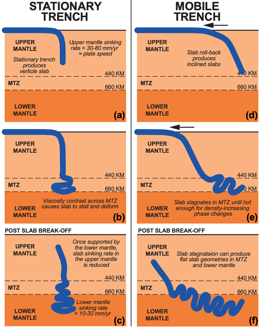
The India-Asia collision built the Himalayas and Tibetan Plateau, but fundamental questions remain: when exactly did India collide with Asia? How large was Greater India before collision? What happened to the vast Tethys Ocean that once separated them? This study tackles these questions by integrating three independent lines of evidence: bedrock geology from Tibet recording ancient subduction, seismic tomography imaging subducted slabs now deep in the mantle, and plate kinematic reconstructions. The figure illustrates how slab geometries depend on trench behavior: stationary trenches (a-c) produce vertical or slightly tilted slabs, while mobile trenches (d-f) create more complex geometries. By assuming slabs sink vertically and matching their positions to paleo-trench locations, we test three competing models for Greater India's size. The analysis reveals that no single model satisfies all constraints, suggesting our understanding of suture zones and continental subduction limits needs revision.
Abstract
In this study, we integrate bedrock datasets, observations of subducted slabs in the mantle, and plate kinematic constraints to constrain models for the India-Asia collision and the central Tethys oceans. To accomplish this, we review: (1) the post-Triassic bedrock record of subduction in Tibet; (2) seismic tomographic imaging of subducted slabs in the mantle; (3) timing of the India-Asia collision; and (4) the pre-collisional size of Greater India. Following the assumption that slabs sink vertically through the mantle, their positions and geometries determined from seismic tomography constrain the locations and kinematics of paleo-subduction zones. Integrating this with bedrock constraints allows us to constrain post-Triassic subduction zone configurations for the central Tethys oceans. Neotethys was consumed by at least two subduction zones since the Jurassic. At the onset of the India-Asia collision at 59 ± 1 Ma, one subduction zone was active along the southern Asian continental margin at ~20°N. At that time, a second may have been active at subequatorial latitudes, but support for this from a bedrock perspective is lacking. This subduction zone configuration allows for three reconstructions for Greater India: The (1) minimum-area; (2) enlarged-area; and (3) Greater India Basin reconstructions. We integrate these reconstructions and subduction zone configurations in a plate kinematic framework to test their validity for the India-Asia collision. No single model is entirely satisfactory and each invokes assumptions that challenge accepted concepts. These include our understanding of suture zones, and the limits of continental subduction. We explore these challenges and their implications for our understanding of the India-Asia collision and continental collisions in general.
Keywords: India-Asia collision, Tethys oceans, seismic tomography, subduction zones, plate tectonics, Greater India
Citation
Please cite this work as:
Andrew J. Parsons, Kasra Hosseini, Richard M. Palin, Karin Sigloch. "Geological, geophysical and plate kinematic constraints for models of the India-Asia collision and the post-Triassic central Tethys oceans". Earth-Science Reviews (2020). https://doi.org/10.1016/j.earscirev.2020.103084
Or use the BibTeX citation:
@article{PARSONS2020103084,
title = {Geological, geophysical and plate kinematic constraints for models of the India-Asia collision and the post-Triassic central Tethys oceans},
journal = {Earth-Science Reviews},
volume = {208},
pages = {103084},
year = {2020},
issn = {0012-8252},
doi = {https://doi.org/10.1016/j.earscirev.2020.103084},
url = {https://www.sciencedirect.com/science/article/pii/S0012825219303514},
author = {Andrew J. Parsons and Kasra Hosseini and Richard M. Palin and Karin Sigloch},
abstract = {In this study, we integrate bedrock datasets, observations of subducted slabs in the mantle, and plate kinematic constraints to constrain models for the India-Asia collision and the central Tethys oceans. To accomplish this, we review: (1) the post-Triassic bedrock record of subduction in Tibet; (2) seismic tomographic imaging of subducted slabs in the mantle; (3) timing of the India-Asia collision; and (4) the pre-collisional size of Greater India. Following the assumption that slabs sink vertically through the mantle, their positions and geometries determined from seismic tomography constrain the locations and kinematics of paleo-subduction zones. Integrating this with bedrock constraints allows us to constrain post-Triassic subduction zone configurations for the central Tethys oceans. Neotethys was consumed by at least two subduction zones since the Jurassic. At the onset of the India-Asia collision at 59 ± 1 Ma, one subduction zone was active along the southern Asian continental margin at ~20°N. At that time, a second may have been active at subequatorial latitudes, but support for this from a bedrock perspective is lacking. This subduction zone configuration allows for three reconstructions for Greater India: The (1) minimum-area; (2) enlarged-area; and (3) Greater India Basin reconstructions. We integrate these reconstructions and subduction zone configurations in a plate kinematic framework to test their validity for the India-Asia collision. No single model is entirely satisfactory and each invokes assumptions that challenge accepted concepts. These include our understanding of suture zones, and the limits of continental subduction. We explore these challenges and their implications for our understanding of the India-Asia collision and continental collisions in general.}
}