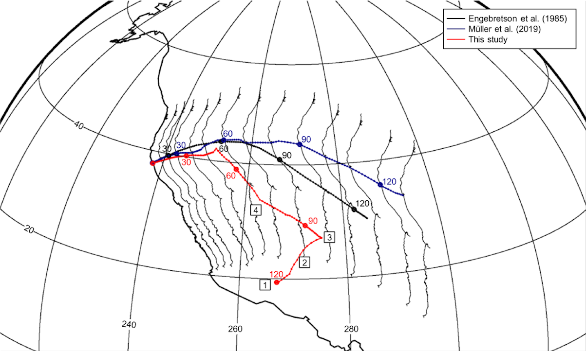
We present a quantitative plate reconstruction of western North America and the eastern Pacific basin (170 Ma to present) using "tomotectonic analysis" - integrating seismic tomography of subducted lithosphere in the mantle with surface geological data. This figure shows the trajectory of San Francisco relative to the lower mantle across different reconstructions. Previous models (black, blue) assumed continuous Farallon subduction beneath the continental margin. Our reconstruction (red) reveals a fundamentally different four-stage evolution: (1) stationary along the intraoceanic Alisitos trench, (2) transfer to the Farallon plate moving northeastward, (3) accretion and continued growth in the continent-hugging trench, and (4) northward translation to present latitude. By locating vanished plates in the deep mantle and pairing paleotrench locations with extinct arc volcanoes, we demonstrate that the eastern Pacific was broken into several smaller plates with simultaneous eastward and westward subduction under a vast archipelago, contrasting sharply with the long-held view of simple eastward Farallon subduction.
Abstract
Plate reconstructions since the breakup of Pangaea are mostly based on the preserved spreading history of ocean basins, within absolute reference frames that are constrained by a combination of age-progressive hotspot tracks and paleomagnetic data. The evolution of destructive plate margins is difficult to constrain from surface observations as much of the evidence has been subducted. Seismic tomography can directly constrain paleotrench locations by imaging subducted lithosphere in the mantle. This new evidence, combined with the geological surface record of subduction, suggests that several intraoceanic arcs existed between the Farallon Ocean and North America during late Mesozoic times—in contrast to existing quantitative models that typically show long-lived subduction of the Farallon plate beneath the continental margin. We present a continuously closing plate model for the eastern Pacific basin from 170 Ma to present, constrained using “tomotectonic analysis”—the integration of surface and subsurface data. During the Middle to Late Jurassic, we show simultaneous eastward and westward subduction of oceanic plates under an archipelago composed of Cordilleran arc terranes. As North America drifts westward, it diachronously overrides the archipelago and its arcs, beginning in the latest Jurassic. During and post-accretion, Cordilleran terranes are translated thousands of kilometers along the continental margin, as constrained by paleomagnetic evidence. Final accretions to North America occur during the Eocene, ending ~100 Myr of archipelago override. This model provides a detailed, quantitative tectonic history for the eastern Pacific domain, paving the way for tomotectonic analysis to be used in other paleo-oceanic regions.
Plain Language Summary
Tectonic plate reconstructions back to the Jurassic period are mostly based on data from preserved ocean crust. However, many oceanic plates have been lost into the Earth’s interior by subduction, making their reconstruction a challenge. We combine seismic images of the deep mantle with geological data to locate the vanished plates in the Earth’s mantle and restore them to their previous positions at the surface. The trenches where the plates subducted can be paired with extinct arc volcanoes in western North America. Jointly, these lines of evidence suggest that the eastern Pacific basin was broken up into several smaller plates—in contrast to the long-held view that one or two large plates subducted eastward beneath the west coast of North America for the last 170 Myr. Instead, we model simultaneous eastward and westward subduction of plates under a vast archipelago of volcanic arcs that sat stationary in the northeastern proto-Pacific. North America was pulled westward into this archipelago and gradually collided with its microcontinents, which today form the North American Cordillera. Our model provides a more detailed and complete tectonic history for the eastern Pacific and highlights how our method can be used to reconstruct vanished oceans.
Keywords: tomotectonic analysis, plate reconstruction, seismic tomography, North America, Farallon plate, subduction, Cordilleran terranes
Citation
Please cite this work as:
Edward J. Clennett, Karin Sigloch, Mitchell G. Mihalynuk, Maria Seton, Martha A. Henderson, Kasra Hosseini, Afsaneh Mohammadzaheri, Stephen T. Johnston, R. Dietmar Müller. "A Quantitative Tomotectonic Plate Reconstruction of Western North America and the Eastern Pacific Basin". Geochemistry, Geophysics, Geosystems (2020). https://doi.org/10.1029/2020GC009117
Or use the BibTeX citation:
@article{https://doi.org/10.1029/2020GC009117,
author = {Clennett, Edward J. and Sigloch, Karin and Mihalynuk, Mitchell G. and Seton, Maria and Henderson, Martha A. and Hosseini, Kasra and Mohammadzaheri, Afsaneh and Johnston, Stephen T. and Müller, R. Dietmar},
title = {A Quantitative Tomotectonic Plate Reconstruction of Western North America and the Eastern Pacific Basin},
journal = {Geochemistry, Geophysics, Geosystems},
volume = {21},
number = {8},
pages = {e2020GC009117},
doi = {https://doi.org/10.1029/2020GC009117},
url = {https://agupubs.onlinelibrary.wiley.com/doi/abs/10.1029/2020GC009117},
note = {e2020GC009117 2020GC009117},
abstract = {Abstract Plate reconstructions since the breakup of Pangaea are mostly based on the preserved spreading history of ocean basins, within absolute reference frames that are constrained by a combination of age-progressive hotspot tracks and paleomagnetic data. The evolution of destructive plate margins is difficult to constrain from surface observations as much of the evidence has been subducted. Seismic tomography can directly constrain paleotrench locations by imaging subducted lithosphere in the mantle. This new evidence, combined with the geological surface record of subduction, suggests that several intraoceanic arcs existed between the Farallon Ocean and North America during late Mesozoic times—in contrast to existing quantitative models that typically show long-lived subduction of the Farallon plate beneath the continental margin. We present a continuously closing plate model for the eastern Pacific basin from 170 Ma to present, constrained using "tomotectonic analysis"—the integration of surface and subsurface data. During the Middle to Late Jurassic, we show simultaneous eastward and westward subduction of oceanic plates under an archipelago composed of Cordilleran arc terranes. As North America drifts westward, it diachronously overrides the archipelago and its arcs, beginning in the latest Jurassic. During and post-accretion, Cordilleran terranes are translated thousands of kilometers along the continental margin, as constrained by paleomagnetic evidence. Final accretions to North America occur during the Eocene, ending ~100 Myr of archipelago override. This model provides a detailed, quantitative tectonic history for the eastern Pacific domain, paving the way for tomotectonic analysis to be used in other paleo-oceanic regions.},
year = {2020}
}