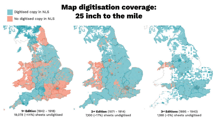
Although the Ordnance Survey has been the subject of historical research, scholars have not systematically used its maps as primary sources, partly due to technical barriers in accessing and processing large collections. This paper outlines a computer vision pipeline for analyzing thousands of digitized 25-inch Ordnance Survey maps simultaneously rather than individually. The visualization shows digitization coverage across different map editions, revealing where sheet holdings remain undigitized and how coverage varies between editions. By creating item-level metadata and applying machine learning methods to extract spatial features, the 'patchwork method' transforms map collections into interrogable corpora. This approach enables new forms of historical inquiry based on spatial analysis and allows scholars to adopt an overall view of territory. The paper highlights parallels between today's users of digitized maps and nineteenth-century predecessors who faced a similar inflection point as the project to map the nation approached completion.
Abstract
Although the Ordnance Survey has itself been the subject of historical research, scholars have not systematically used its maps as primary sources of information. This is partly for disciplinary reasons and partly for the technical reason that high-quality maps have not until recently been available digitally, geo-referenced, and in color. A final, and crucial, addition has been the creation of item-level metadata which allows map collections to become corpora which can for the first time be interrogated en masse as source material. By applying new Computer Vision methods leveraging machine learning, we outline a research pipeline for working with thousands (rather than a handful) of maps at once, which enables new forms of historical inquiry based on spatial analysis. Our ‘patchwork method’ draws on the longstanding desire to adopt an overall or ‘complete’ view of a territory, and in so doing highlights certain parallels between the situation faced by today’s users of digitized maps, and a similar inflexion point faced by their predecessors in the nineteenth century, as the project to map the nation approached a form of completion.
Keywords: Ordnance Survey, digitized maps, Computer Vision, machine learning, historical research, spatial analysis, digital humanities, Victorian maps
Citation
Please cite this work as:
Kasra Hosseini, Katherine McDonough, Daniel van Strien, Olivia Vane, Daniel C. S. Wilson. "Maps of a Nation? The Digitized Ordnance Survey for New Historical Research". Journal of Victorian Culture (2021). https://doi.org/10.1093/jvcult/vcab009
Or use the BibTeX citation:
@article{10.1093/jvcult/vcab009,
author = {Hosseini, Kasra and McDonough, Katherine and van Strien, Daniel and Vane, Olivia and Wilson, Daniel C S},
title = {Maps of a Nation? The Digitized Ordnance Survey for New Historical Research},
journal = {Journal of Victorian Culture},
volume = {26},
number = {2},
pages = {284-299},
year = {2021},
month = {04},
issn = {1355-5502},
doi = {10.1093/jvcult/vcab009},
url = {https://doi.org/10.1093/jvcult/vcab009},
eprint = {https://academic.oup.com/jvc/article-pdf/26/2/284/39315638/vcab009.pdf}
}